Monday, December 16, 2013

End of 2013 cruising

Our 2013 cruising season is officially over. Down Time was hauled out of the water November 22 and stored at a boat yard in Mobile, Alabama. We had originally planned to leave her in a marina on the Tennessee River near Huntsville. But when we arrived there in September we didn't really like the place, despite all of the good reviews other boaters had given it. We needed to stop in a boat yard in Mobile to have some work done anyway, so we decided to head there to store the boat. This will save us a couple of weeks in the Spring when we go back to the boat.

DT being hauled to her storage spot

Mobile is an active ship construction and maintenance harbor. On our way to the yard we passed this strange looking ship.


Turns out that this is the USS Jackson which was built in Mobile and officially launched on December 14. It is a new class of vessel called a littoral combat ship. Wikipedia says:

"The littoral combat ship (LCS) is a class of relatively small surface vessels intended for operations in the littoral zone (close to shore) by the United States Navy. It was 'envisioned to be a networked, agile, stealthy surface combatant capable of defeating anti-access and asymmetric threats in the littorals.' The LCS designs add the capabilities of a small assault transport with a flight deck and hangar large enough to base two Seahawk helicopters, the capability to recover and launch small boats from a stern ramp, and enough cargo volume and payload to deliver a small assault force with fighting vehicles to a roll-on/roll-off port facility."

The other strange thing we saw was this tented ship.


It looks just like a house that was being treated for an infestation of termites would look. I didn't want to think about what they might be trying to eradicate on the ship.

So happy holidays everyone. We'll be back on the boat around mid-April. Next year's adventures include cruising to New Orleans, touring around Cajun country, a trip across the panhandle of Florida, and a return to Marathon, Florida where we will officially end our six year adventure. 

See you in the Spring.

Friday, November 15, 2013

Tennessee Tombigbee Waterway

We are half way through the Tennessee Tombigbee Waterway, the Army Corps of Engineers created link between the Tennessee River and the Gulf of Mexico. The Tombigbee River was a commercial river as early as the 1830s, although river boats could only run on it during the rainy season, which ran from November to April. The rest of the year there wasn't enough water to support even the shallow draft paddle-wheelers. The locals started agitating to dam the river and connect it to the Tennessee as early as the 1870s, although Congress didn't approve the project until the late 1940s and didn't fund it until the 1970s. There is a 25 mile ditch dug between the Tennessee and the headwaters of the Tombigbee and a series of dams that ensure the river remains deep enough to support year round commercial tug/barge traffic.

Tenn Tom ditch
There are several large creeks in the area where the ditch was dug, but the ditch is too narrow to let those creeks flow directly into the ditch. The water flow would push traveling boats, especially small pleasure craft all over the narrow ditch. So the Corps of Engineers devised these special flow control areas to break up the creeks and feed the water gently into the Tenn Tom.


We had a first on the boat this week. It was actually too cold to move the boat.  In the three weeks since we left the Knoxville area, we have had 5-7 days of below 30 degree temperatures. Some boats are built with heaters that run off of propane or diesel fuel. As a Florida-built boat, Down Time has a heat pump that provides both heat and air conditioning, just like a home heat pump does. But the heat pump runs on 110 volt power which we can get either by plugging into a marina's power or by running our generator. If we are in a marina, no problem. But if we anchor out and the temperature drops below freezing, the only way to keep from freezing ourselves would be to run the generator all night. Not a good idea. So we ended up staying an extra day in the marina in Columbus, Mississippi because the forecast was for 25 degrees.

We have also discovered that in extremely cold temperatures, it rains inside the boat. The warm air inside the boat meets the cold temperature outside the boat at the plexiglas hatches, condenses on the inside of the hatches and then drops from the hatches (which are installed at an angle) onto the surface below. Unfortunately, one of the surfaces below two of the big hatches is our bed, specifically my side of our bed. Nothing like a good splash to wake you up in the middle of the night. We've owned the boat for ten years and are just discovering this "feature." I don't guess it will be a problem when we get back to Florida, but for now it is driving me crazy.

This part of the country, Alabama and Mississippi, is timber country. There are lots of tree farms and wood processing plants in this area and there are a reasonable number of logs and tree limbs floating in the water of the rivers. You pay attention and maneuver around them with your boat. Yesterday, Jim was driving and we both saw what we thought were partially submerged logs. But they were moving very strangely. I grabbed the binoculars to see what was going on and saw this -- two dogs swimming across the river.  They weren't this least bit panicked, clearly knew where they were going and had done this before. Gave us quite a start, though.

Dogs crossing the Tenn Tom
Today we passed the White Cliffs of Epes, Alabama. You've heard of the White Cliffs of Dover in England? Well, these are much smaller, but made from the same chalk-like substance as the bigger cliffs in England.


The rest of the area is trees to the waterline and then you come to this startling 1/8 to 1/4 mile long set of white walls on one side of the river. No where else on the river looks anything like this. Most of the shoreline is trees in various stages of Fall colors.

I'll close this post with some shots of the colors in the trees.


Next week we'll be in Mobile and the week after that we'll be home!

Wednesday, November 6, 2013

Leaving the Tennessee River

We have traveled nearly 400 miles from our northern-most point on the Tennessee River back to Iuka, Mississippi. This is where we will leave the Tennessee River and begin traveling down the Tombigbee River to Mobile, Alabama. Mobile is our final destination for this year. We'll have the boat hauled out of the water there and stored on land until sometime next Spring. One reason to have the boat hauled is because next year we'll be back in salt water for the first time in four years. A boat in salt water needs anti-fouling paint on the hull, so we'll get the yard to apply the bottom paint while we are back home for the holidays.

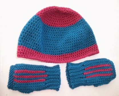
The trip down the Tennessee has been much quicker than the trip up. First of all, the river current is flowing with us, so we are are traveling 1.5 - 2.0 knots per hour faster at the same engine speeds. Another reason for the speed down is the weather. The weather has been very changeable (I guess that is pretty much the definition of Fall, isn't it?) It seems that for every pleasant, sunny day we've had, there have been two overcast, cold days. One morning it was 25 degrees on the back deck when we woke up. Since I am the one who catches the bollard and rides on the deck as we go through the locks, I found these chilly days somewhat of a chore, especially since we always try to go through the locks in the morning if we can (to allow time to deal with unexpected delays if needed). The first shivering through a locking down resulted in a new hat and glove set for me. Actually, I had already made the fingerless gloves as a way to learn a new crochet technique, so I was able to whip up the hat using the left over yarn while we traveled between locks.
Warm wool boating accessories
I realize that I mentioned the "catching the bollard" above, yet I may not have explained that in previous blog posts. The locks on these rivers are much higher than the locks on the Erie Canal or in Canada. There the locks have ropes hanging on the walls and you pick one or two up as you enter the lock, hook it to a cleat on your boat and and take it up (or let it out) as your boat goes up or down in the lock. But when the lock is 50 - 90 feet deep, taking up or letting out that much line simply isn't practical. So in these locks you pull up to a bollard, wrap one of your own lines around it, and it floats up or down with the boat as the lock fills or empties. But sometimes these bollards get hung up and stop rising or dropping with the water. If that happens your boat can be damaged quickly, so you don't get to tie the line to the bollard and then step back into the warm cockpit. You need to hold the line and be constantly prepared to let it go if a problem develops, which explains why I needed the hat and the gloves.
Lock floating bollard
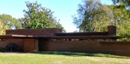
We did make a couple of stops on the trip down river to see things we hadn't seen on the way up. Jim's sister Melanie joined us for a few days of cruising, including a return to Florence, Alabama. Florence has the only Frank Lloyd Wright house built in the state of Alabama. When we first visited Florence, the house was closed, so we made it a point to schedule our return on a day the house would be open for touring.

Front of the house
There is no question when you are driving around the neighborhood which house you are looking for, it is a classic Wright house.  The back is a little less stark with a great wall of windows that overlooks the generously sized backyard.


The house was owned by one family for nearly 60 years. The money to build it was given to the couple as a wedding present by her parents in the early 1940s. They were newlyweds when they built it, but over time they had four sons, so it became the only Frank Lloyd Wright house for which Wright designed and built an addition. As is typical of an FLW house, he designed the furniture and even the lighting fixtures, much of which has been preserved. Every built in light in the house had this design. Apparently, each house he built had it's own light design.

Lighting detail

Living room furniture designed by Wright
Note the lovely turquoise furniture contrasting with the brown walls and floors. The "service area" (FLW-speak for kitchen) in the original house was a 4 ft x 4 ft cubby off of the dining room, so when she commissioned the addition, Mrs. Rosenbaum requested a more functional food preparation space. This is the stove she got when the addition was built in the 50s, a stove she used until the late 1990s when she finally left the home.


I would have coveted it if it had been gas, not electric.

The most amazing part of the Wright house story is how it came to be a tourist attraction in Florence, Alabama. By the time Mrs. Rosenbaum left the house, it was falling down around her. The city of Florence put a tax initiative on the ballot to increase the local sales tax to raise $600,000 to buy and re-hab the house. And the voters of Florence voted "yes". Can you imagine that happening today?

The other attraction we missed heading up river was the Apron Museum in Iuka, Mississippi. There are over 2,000 aprons in the collection, some dating from the civil war. There are men's aprons as well as women's aprons, although most of the collection is hand decorated "hostess aprons" from the 1950s.

Iuka, MS Apron Museum

Samples of 1950s hostess aprons
It is amazing to think of the time and attention to detail women spent on these things when they were stuck in the home during the 50s, with few outlets for their creative or artistic interests. As a needleworker myself, I was fascinated by craftsmanship of many of the pieces. The woman who owns the museum accepts donations and always tries to get stories from the women who make the donations about the history of the aprons and their family members who made them. She is not only collecting aprons, she is preserving the histories of women who would otherwise be forgotten. If you happen to be in Iuka, Mississippi, it is a fun stop.


Tuesday, October 22, 2013

Little Tennessee River and the Great Smoky Mountains

We have made it as far north as we are going on the Tennessee River, to Lenoir City about 50 miles south of Knoxville. I know we said we were headed to Knoxville, but Fall is really falling around here. We've gone from the high 70s and low 80s during the day to the mid to low 50s in little more than a week. Two days from now the low will be 27. I know to my family living in Salt Lake and our friends in Cleveland that doesn't sound so bad, but we are on a boat and boats are not known for their insulation. Its getting cold here.

We have been having a wonderful time since we left Chattanooga.  Most people doing the Great Loop cruise never even get to Chattanooga and even fewer head further north, but believe me, they miss the best part of the trip. The lakes north of Chattanooga are surrounded by hills with forest running all the way to the water line. The river twists and turns through canyons giving you great views around every corner. As you get further north the Great Smoky Mountains become the backdrop behind the Tennessee River hills. It is all just stunning to see.
Smokies in the distance
Our friend Ron Westbrook from Texas drove up to spend some time with us and we went cruising up the Little Tennessee River and Tellico Lake. Tellico Lake is the last lake formed by a TVA dam. The TVA decided it needed to dam the Little Tennessee River at the point it connects with the Tennessee for flood control purposes. They started building the dam in the 1960s and folks around here went nuts. The Little Tennessee was the last naturally flowing river in this area and there was tremendous opposition to damming it. The development was tied up in the courts for over 10 years and the lake wasn't created until 1979. I'm not sure that we would have been able to take a boat as big as Down Time into the Little Tennessee if the dam hadn't been built, so I'm grateful for the dam.

Because Tellico Lake is so new, some of the structures in the areas that were flooded are still standing. These three silos are poking out of the water marking the location of a farm that was flooded.


For so new a lake, there is a surprising amount of residential development around the northern end of Tellico Lake, the area around Knoxville. Lots of very expensive and reasonably ugly monster homes line the banks of the lake. But as you get further south, the housing thins out and by the time you get to to foot of the Smokies, you are back in nearly undeveloped land.

This is the area the Cherokees inhabited before they were driven out to Oklahoma on the Trail of Tears. The Cherokees fought for the British/Americans in the French and Indian War (1754-1763). Before the men would head off to fight, they asked the British to build a fort to provide protection for their women and children. The fort site was thoroughly excavated during the time of the anti-Tellico Lake lawsuits and the point of land on which it had stood was built up to ensure that it wouldn't be covered by the new lake. Then the fort itself was recreated on the site. We anchored off the fort and took our dinghy in to walk around and learn more about the history of this area.

Fort Louden
While we were at the fort, the ranger (state park employee, not a furloughed federal worker thankfully), told us about the Sequoyah Birthplace museum just a mile up the river. Like probably most of you, I had heard the name Sequoyah but couldn't have told you more than he was a 19th century Native American. Turns out he was the man who single-handedly developed the Cherokee alphabet, the only known instance in history of an alphabet being developed by a single person. Even more amazing, once the Cherokees understood what he had done, the entire tribe (approximately 30,000 people) were able to read and write within a year.

From Fort Louden we continued south to the end of the marked channel on the Little Tennessee River, as far a you can safely take a boat as big as ours. We anchored at the foot of the Great Smoky Mountains.

Foot of the Smokies
As the days have cooled down, we are also getting mist rising up from the river in the morning.


Some days the "mist" is a thick fog. Yesterday, the boat next to us in the marina had to wait until 11:00 AM for the fog to burn off enough to move, another indication that it is time to head south.

One other stop we made on the way up the Tennessee was Dayton, TN, site of the Scopes Monkey trial in 1925. You may remember (or you may have seen the Spencer Tracy movie Inherit the Wind) that the Scopes trial was about teaching evolution in the schools. The courthouse in which the trail was held is still in use today. In fact the same spectator chairs, judge's bench and jury chairs that were there in 1925 are still there today. Many of the same businesses are still operating. Dayton is a small town that hasn't changed much at all. They do have a nice little museum about the trail in the basement of the courthouse.

Jim at the Clarence Darrow/Spencer Tracy podium

Original spectator chairs
On the way up the river the trees were still mostly green with just a hint that fall colors were to come. I suspect that we will see some beautiful colors on our way south. We will try to capture some of the best views to share with you. Think positive thoughts about us getting out of here without freezing to death.

Tuesday, October 8, 2013

The Nina, the Pinta and the ... Down Time?

We've seen some interesting things boating up the Tennessee River, but the most interesting, so far, has to be the replicas of Columbus' boats, the Nina and the Pinta.  Our first hint of their existence came when we called the city marina in Florence, Alabama, to reserve a slip for the night and the dockmaster told us to just pull in in front of the "Christopher Columbus boats."


These are the two life size replicas we caught up with in Florence.  They are crewed by volunteers who ride on them through various locations, stopping for 2-3 days and selling opportunities for people to see them.  We had heard they were in Grand Rivers Kentucky when we were there although we did not see them. From Florence they were headed up the Tennessee to Decatur, Alabama, and then Knoxville, Tennessee.  Just to give you an idea of how big they are, here is a picture with Down Time, a 36 foot boat.


As you can see, they make Down Time look small.

We actually left Florence with the Nina and Pinta headed upriver. Just  past Florence is the Wilson Dam and lock, the tallest lock on the Tennessee River. Having the Nina and Pinta to photograph gives me an opportunity to help illustrate just how big this lock is.


Wilson Lock gates opening
This is what the lock gates look like when they are opening in front of you.  And here is how small the Nina and Pinta look inside the lock.
Nina and Pinta in the lock
This is my view of the lock looking up, waiting for the lock to fill.


These are the depth gauges on the boat during our locking through in the Wilson Lock.  The top one shows we had 16 feet of water under the boat when we entered the lock and the bottom one shows the 111 feet of water under us when we reached the top of the lock.


Entering depth
Exiting depth
We had one other lock to get through after the Wilson Lock the day we traveled with the Nina and Pinta.  We could have passed the two replica boats and hurried up to the next lock, but the lock tender would very likely have held us there waiting for the replica boats, so we just held back and followed them up Wilson Lake. It was actually quite fun to watch the reactions of the local boaters who saw these two fifteenth century galleons crossing their lake.  One guy came out on his jet ski to circumnavigate the two boats.

The other fun thing we saw was this sign in Decatur, Alabama, positioned to be viewed from the river. I guess every place has to be proud of something. In Decatur, it's cat food.


Tuesday, October 1, 2013

Tennessee River and Chattanooga

For those of you who figured that we must have fallen off the face of the earth, I am pleased to report we are alive and well. Since our last posting we have been cruising up the Tennessee River from Grand River, Kentucky to Chattanooga, Tennessee. The river is very sparsely inhabited, which means that there is very little cell phone service/Internet access. Chattanooga is the first place we have had decent Internet access in over a month.

We have thoroughly enjoyed the river, however. We left Grand River with our Miami friends, Rob and Carol Harris, on board on Labor Day.  We found wonderful, empty anchorages to spend nights in and Carol even swam in the river while we were anchored. A week after the Harrises left us, our friends Bill and Birute Fleck from Charlevoix, MI, joined us in Guntersville Lake, Alabama, and rode with us to Chattanooga. We had a couple of days of overcast weather while they were on board, but scenes like this bridge more than made up for the grey.

Tennessee River bridge

We are headed up the Tennessee towards Knoxville. The further upriver we go, the closer we get to the Smoky Mountains. When we left Kentucky, the river was wide and the surrounding land was flat. The eastern shore of the river is the Land Between the Lakes, a national recreational area formed by Kentucky Lake and the creation of Lake Barkley on the Cumberland River in the 1960s. In the 18th and early 19th centuries, this area was roamed by herds of bison and elk numbering in the thousands. Although the area is now covered in trees, then it was flat prairie because the herds kept the trees from growing. The USDA, which manages the recreational area, has re-introduced a herd of 50 bison and nearly 40 elk into the area. We didn't see any elk while we were touring, but the bison have no qualms about hanging out near roads where people can see them.

Baby bison


Herd just off the road
The Tennessee Valley Authority, a federally owned corporation created by congressional charter in 1933 to provide navigation, flood control, electricity generation and economic development in the Tennessee Valley, owns most of the riverfront on the Tennessee River because they created lakes by damming the river to generate electricity. The lakes flooded the towns and farms that had existed along the riverbanks and the TVA had to buy out the original owners. You can motor up the river for miles and miles without seeing a single building. Even when you do come to an area where there are riverfront homes, often they are trailers, or even just RVs on the riverbank. Interestingly, most of the RVs are parked under sheds, some with screened porches on the front and garages for the owner's car.

RV under its riverside shed

Single-wide trailer built to withstand flooding


As you get further up the river, you begin to enter the foothills of the Smokies. Hills become more common and you see limestone cliffs on the side of the river. The further you go, the more forested the hills become. The trees haven't started turning colors yet, but we are assured that the colors will be spectacular during the last couple of weeks in October.
Limestone cliffs on the Tennessee River

Chattanooga is the first real city we've spent time in since Chicago. I was here briefly twenty years ago and it has changed a lot. The wealthy residents decided about 15 years ago to clean up the waterfront and begin to market the city as a sports destination, emphasizing water sports like kayaking and paddle-boarding, mountain biking, hiking, and other outdoor sports. It is attracting 20-somethings and young families to live here and has a vibrant restaurant and bar scene. There is lots to do and it is a very walkable city with good public transportation. Bill and Birute brought their car from Guntersville to Chattanooga after we got here and we used it to tour around a bit, including a trip up to the top of Lookout Mountain. Lookout Mountain has the steepest incline railroad in the world and a great view of the surrounding area. They claim you can see seven states from the top, but I think that is more hype than truth.

Incline Railway

View from top of Lookout
On our way back to the boat from Lookout Mountain we stopped to see the International Towing and Recovery Museum, a museum devoted to the history of the tow truck industry. Turns out that the first tow trucks were developed by a company here in Chattanooga. It is a small museum but it has a wonderful collection of tow trucks from the last 100 years and a very large collection of tow truck related toys.


We will be leaving here on Friday and heading further up the river, maybe as far as Knoxville. If we have Internet access, we'll post more frequently. I promise.

Thursday, August 29, 2013

Some missing pictures

You may remember that our camera died during a particularly raucous encounter with barge prop-wash on the Mississippi River. We finally got a replacement for it and the new camera was happy to read the images off of the old camera's storage card. So here are some of the images we couldn't share earlier.

Here is a picture of the first Asian carp that through himself (herself?) in the dinghy. We weren't so charmed by the next three kamikaze carp, didn't take their pictures.
Dead carp
This looks like a lock sitting at the side of the river without a corresponding dam and that is exactly what it is. On the Illinois and Ohio Rivers there are dams called wicket dams that can be raised and lowered to control the depth of the pool behind them. The wickets are pieces of metal that are put in place, or lowered, using a crane on a floating barge. We talked with a lock tender at one dam where the wickets were up and he explained the process to us. That dam had 108 wickets that needed to be individually raised. When you approach a dam with the wickets up from up river you can't see the dam, the lock tenders start the wicket raising process by putting buoys in the water directing boats to the lock. When the wickets are down, you get this weird experience of driving over where the dam should be, bypassing the lock.
Wickets down on the Illinois
The wicket dams can change the depth of the water by 10 or more feet. Of course, the depth of the water changes many times over the course of a single year. We came down the coast of Michigan slowly because the rivers were flooding in May and June. By the time we got to the Mississippi the river was low. When you get to the southern end of the Illinois and the the Mississippi you really understand how much the river levels change. These houses are on the banks of the Mississippi and they are raised two full stories from the ground to the first floor.
River houses
The marinas on the rivers have floating docks. Look at the dark poles in this picture. That is how high the docks can rise as the river rises.
River marina
Even the trees have to deal with the rising and lowering of the water. This tree is in the pool of one of the wicket dams. You can see the line in the tree that marks where the water is when the dam is raised.


This is one barge in a Mississippi tow. Imagine a tow with 8 or 9 of these in a row and 3 or 4 rows lashed together. We are still going to be dealing with tows on the Tennessee River and the Tombigbee waterway, but they won't be as big as the Mississippi River tows.

Mississippi barge
We went past St. Louis on the Mississippi and I had to take the standard St. Louis Arch picture. What I had never noticed before is that the state capitol is actually framed by the arch from the water. 


St. Louis has the worst waterfront of any water front city I have seen. I thought Cleveland had wasted its water front but it has nothing on St. Louis. That "beach" you see in front of the arch is a parking lot. Of course, with all the commercial barge traffic on the Mississippi, and the cities upstream who pump their waste into the river, you wouldn't want to swim in the Mississippi anyway.

We've just come back to the boat after going home to Cleveland for a couple of weeks. Saturday our friends the Harrises arrive for a week's visit and we will start heading up the Tennessee River towards Knoxville.